OFFICIAL OPENING OF AVON RIVER BRIDGE, TOODYAY
1968B & W photo.
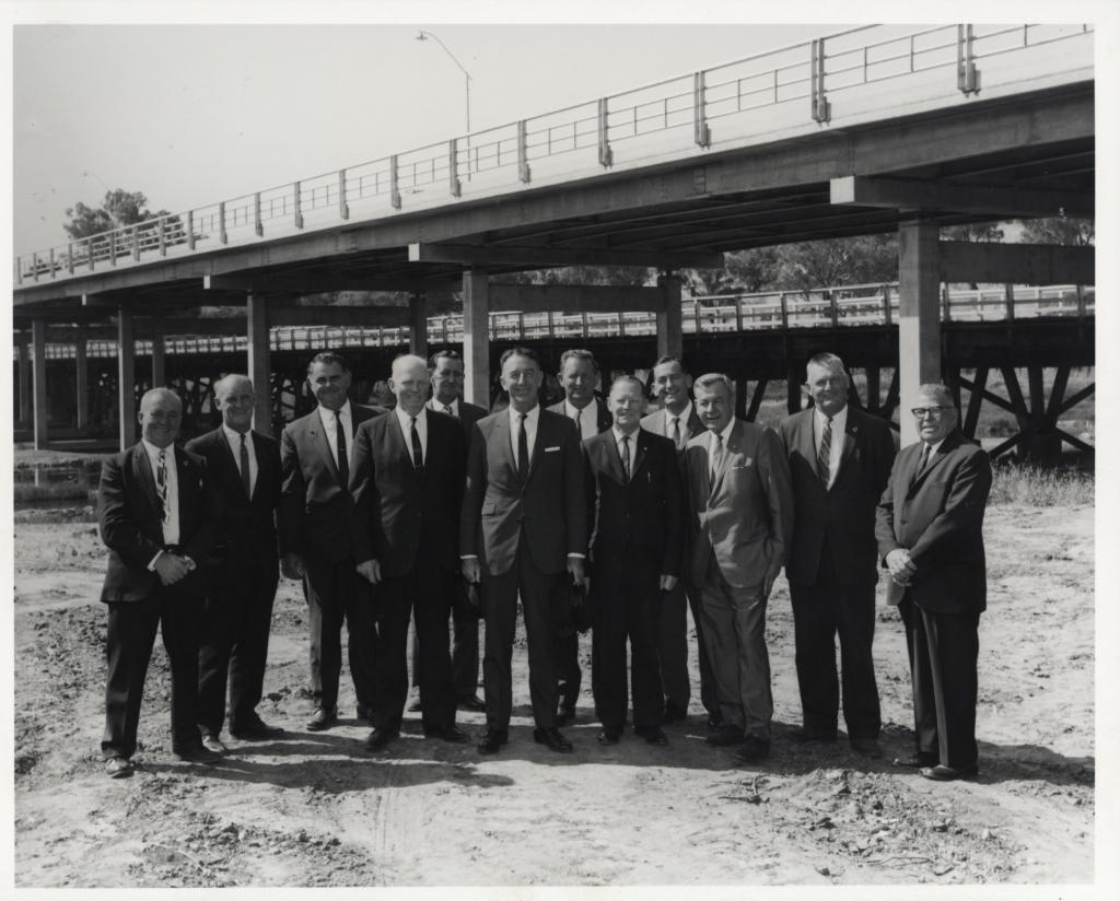
11 Councillors & Shire Clerk of the Toodyay Shire Council.
The official opening of the Avon River Bridge (later renamed the Newcastle Bridge), by the Minister for Works.
Behind the new structure can be seen the former wooden bridge which was later demolished.
A small amount of water can be seen to the left middle of photo, and the top of a tree is visible above the bridge at the top left of the photo.
L-R. R. Preston ( Shire Clerk), A. J. North ( Councillor), M.J.Butterly (Councillor), D.E. Ludemann (President), R.J. McKay (Councillor), R.Hutchinson (Minister for Works), J.C. Wroth (Councillor), K.D. Lee (councillor), D.H. Aitken (Commissioner of Main Roads), J.M. Craig (Member for Toodyay), I.V. Murray (Vice President), A.A. Heath (Councillor).
Details
Details
Text on the reverse of photo reads, in part, "The bridge…replace an old timber structure which was subject to occasional flooding. The limit on the old bridge, which can be seen behind the new bridge, was about 40 tons. The new bridge, which is 530 feet long and 26 feet wide between kerbs, was designed and financed the Main Roads Department and built by R.P. Constructions Pty. Ltd. It could carry a 200 ton transformer on an appropriate low loader."
The new ‘Avon River Bridge’, as it was named on that occasion, was officially opened by the Minister for Works, Ross Hutchinson, in the presence of Members of Parliament, the Commissioner of Main Roads, Shire Councillors and hoards of onlookers. The bridge was designed and financed by the Main Roads Dept., built at a cost of $245,000 by R.P. Constructions Pty. Ltd., and had a length of 530 feet and a width of 26 feet between the kerbs.
The afternoon tea for this occasion was catered by the Toodyay Anglican Church Guild, probably held in the nearby St. Stephen’s Church Hall. Les Purser had the distinction of being the first person to cross the newly opened bridge, after the boom gates were raised. Postman Les rode his bicycle, and went on with his job of delivering telegrams, to the cheers of the onlookers.
Open in Google Maps
Nearest geotagged records:
- AVON RIVER IN FLOOD, TOODYAY, 1930 (0.04km away)
- BOARDING HOUSE DURING FLOODS OF 1955 (0.04km away)
- NEWCASTLE BRIDGE AND AVON RIVER IN FLOOD 1930 (0.04km away)
- AVON RIVER IN FLOOD AT NEWCASTLE BRIDGE, TOODYAY 1936 (0.05km away)
- FLOOD AT NEWCASTLE BRIDGE (0.05km away)
- TOODYAY BOARDING HOUSE; FLOODED 1955 (0.06km away)
- ROAD BRIDGE OVER FLOODED AVON, LOOKING TOWARDS NORTH TOODYAY 1915 (0.07km away)
- TOODYAY FLOOD 1952 OR 1953 (0.07km away)
- TOODYAY AVON RIVER FLOOD 1952 (0.07km away)
- AVON RIVER IN FLOOD AND TOODYAY RAILWAY BRIDGE, 1930 (0.07km away)
Nearby places: View all geotagged records »
Other items from Shire of Toodyay
- TIMOTHY FRANCIS QUINLAN
- ST JOHN THE BAPTIST ROMAN CATHOLIC CHURCH
- STACK OF BAGGED WHEAT AT BOLGART SIDING
- SYRED'S COTTAGE, BEJOORDING
- PUPILS DUKE STREET SCHOOL
- TOODYAY SCENE EAST, STIRLING TERRACE
- TOODYAY SCENE, STIRLING TERRACE WEST
- FREEMASONS' HOTEL TOODYAY
- TOODYAY HOMES FOR THE AGED (BUTTERLY COTTAGES)
- SERIES OF PHOTO PROOFS FOR BACK TO TOODYAY SCHOOLS REUNION 1979
- SERIES OF PHOTO PROOFS FOR BACK TO TOODYAY SCHOOLS REUNION 1979
- SERIES OF PHOTO PROOFS FOR BACK TO TOODYAY SCHOOLS REUNION 1979
