DRUMMOND'S MILL, TOODYAY
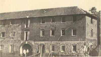
c. 1886 - 1900Small black and white photo of Drummond's Steam Mill at Mill Farm (near Hawthornden).
Three storey brick (on right) and stone (on left and ground storey) building with arched entrance in middle of ground floor, with access doors above and windows on all floors. Shingle roof.
Two figures stand in entrance, probably women. Steam boiler on ground near right hand side of photo, with pipe going through the end wall. Tall/telegraph pole on left side of photo.
Built in 1856/1857 for James Drummond Junior by George Hasell.
James Drummond, botanist and plant collector, was the first settler in the Toodyay Valley, after selecting Location U4 in 1836 and taking up his grant in 1838 after coming to the colony as part of Stirling's official party.
James, his second son, settled on the property and built a cottage. In 1856 he built the steam powered mill and milling commenced in January 1857. .
In 1872, floods destroyed the miller's house at the mill and the mill was threatened.
In 1873 Drummond died from exhaustion and pneumonia after fighting a bushfire and his mill was bought by the Dempster Brothers.
Flour from the mills of both Charles Edward Dempster and Daniel Connor won awards at the Melbourne International Exhibition which ran from 1880 to 1881.
By 1886 the steam mill had been sold to George Throssell,
The building was demolished in 1924
Presumably this photo dates from after the 1880s when the mill was still operating and before (or around) ca1900 when a photograph held by the State Library of WA (066167PD) shows similar broken windows and apparent derelict condition.
Details
Details
On back of photo: stamp "Govt Printing Office Ref TB 3751 Wembley WA"
in pencil: "3618; in pencil: Drummonds Steam Mill, Plate 22 71 iii; in blue ink: Steam Mill built 1857 for James Drummond Jnr [in pencil: by Geo. Hassell [Hasell] passed through many hands. Used for balls (assemblies) in 1880s, damaged by floods and demolished. Bricks used in homes of G. Parkins (Nunyle) and J McPherson (Bolgart). Keystone in possession of Toodyay Road Board. In pencil: [Photo} used in [book] Drummonds of Hawthornden by Rica Erickson, opposite p.137"
Although smaller, this is the same image as the larger, sepia photo in the Shire of Toodyay accession number: 2001.1311
The keystone from the central archway is on display in Connor's Mill, Toodyay. (Shire of Toodyay accession number 2017.20)
Open in Google Maps
Nearest geotagged records:
- DRUMMOND'S STEAM MILL, TOODYAY (0km away)
- WASHAWAY FROM FLOOD AT MILL FARM (0.1km away)
- TOODYAY CEMETERY; ENTRANCE GATES (1.38km away)
- TOODYAY CEMETERY; FUNCTION (1.39km away)
- AVONDALE, TOODYAY (1.56km away)
- AVONDALE SCENE (1.56km away)
- AVONDALE BUILDINGS (1.56km away)
- SANDALWOOD CARTERS (1.67km away)
- HAWTHORNDEN HOMESTEAD, TOODYAY (1.69km away)
- VIEW OF NORTH NEWCASTLE (TOODYAY) (1.87km away)
Nearby places: View all geotagged records »
More items like this
Other items from Shire of Toodyay
- LENGTH OF PILLOW EDGING LACE
- TOODYAY INFORMATION BAY STRUCTURE, TOODYAY ROAD
- SPECTATORS AT TOODYAY RACE CLUB MEETING AT TOODYAY RACECOURSE
- POSSIBLE MINE SITE
- MINE SITE
- ROCK IN PADDOCK NEAR WATERCOURSE
- FOUNDATION STONE OF THE TOODYAY TOWN HALL
- WATERCOURSE IN PADDOCK
- POSSIBLE MINE SITE
- WATER COURSE IN PADDOCK (2)
- OPENING OF NEW TOODYAY SCHOOL 1954
- LENGTH OF LACE
