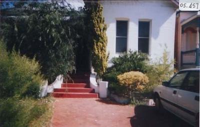
26 Barnfield Road, Claremont
2004Three photographs of the St Louis Estate, 26 Barnfield Road, Claremont (section5).
05.474a
05.474b
05.474c
Views of red brick roof units with black and red roof tiles.
Taken by student at Curtin University's Local History class as part of the Claremont Street Histories Project in 2004.
Details
Details
Open in Google Maps
Nearest geotagged records:
- 22 Barnfield Road, Claremont (0.07km away)
- World War 1, Australia, Western Australia, 3304 McCLEMENTS, 10 Light Horse (0.13km away)
- 10 Barnfield Road, Claremont (0.15km away)
- World War 1, Australia, Western Australia, 523 PHILLP, 10 Light Horse (0.2km away)
- World War 1, Australia, Western Australia, 525 TIPPING, 10 Light Horse (0.21km away)
- 21 Stirling Road, Claremont (0.25km away)
- World War 1, Western Australia Claremont, 44 Battalion, 1916 (0.26km away)
- World War 2, Western Australia, Rottnest Island AIF Enlistment, W233867 to WX29511 TANGNEY, 1942 (0.28km away)
- 'The Grange' Verandah (0.3km away)
- 'The Grange' Garden Croquet (0.3km away)
Nearby places: View all geotagged records »
Copyright and Reference
Copyright and Reference
Acknowledgements to be made to 'Claremont Museum 05.474'.
More items like this
Other items from Town of Claremont Museum
- 28 Barnfield Road, Claremont
- 30 Barnfield Road, Claremont
- 32 Barnfield Road, Claremont
- 36 Barnfield Road, Claremont
- Claremont Teachers College
- 40 Barnfield Road, Claremont
- Site Of Butler's Swamp Siding
- Mews Boat Shed
- Chattie Mcclure
- Chattie McClure
- Claremont Library
- Ron And Coralie White, 66 Victoria Avenue, Claremont
Source: Claremont Museum 05.474a
Source: Claremont Museum 05.474c
Source: Claremont Museum 05.474b
Scan this QR code to open this page on your phone ->


