Read about the Governor Endicott wreck in the Shipwreck database at the Western Australian Museum
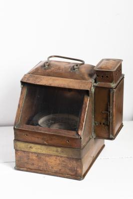
Ship's Brass Compass
This solid and heavy cylindrical compass is attached to the outer brass ring (gimbal) at two points. The gimbal would have been firmly mounted on the ship allowing the compass to stay flat whilst the ship moved with the waves. The base of the compass is enclosed in a very heavy corroded brass shell.
The compass is a magnetometer used for navigation and orientation that shows direction in regards to the geographic cardinal points. The structure of a compass consists of the compass rose, which displays the four main directions on it: East (E), South (S), West (W) and North (N). The angle increases in the clockwise position. North corresponds to 0°, so east is 90°, south is 180° and west is 270°.
The history of the compass started more than 2000 years ago during the Han dynasty (202 BC – 220 AD). The first compasses were made of lodestone, a naturally magnetized stone of iron, in Han dynasty China. It was called the "South Pointing Fish" and was used for land navigation by the mid-11th century during the Song dynasty (960–1279 AD). Shen Kuo provided the first explicit description of a magnetized needle in 1088 and Zhu Yu mentioned its use in maritime navigation in the text Pingzhou Table Talks, dated 1111–1117. Later compasses were made of iron needles, magnetized by striking them with a lodestone. Magnetized needles and compasses were first described in medieval Europe by the English theologian Alexander Neckam (1157–1217 AD). The first literary description of a compass in Western Europe was recorded in around 1190 and in the Islamic world 1232. Dry compasses begin appearing around 1269 in Medieval Europe and 1300 in the Medieval Islamic world. This was replaced in the early 20th century by the liquid-filled magnetic compass.
Whilst Kelvin Hughes Ltd was formed in 1947 by the merger between the well known scientific instrument manufacturing firms of Henry Hughes & Son Ltd, London, England, and Kelvin Bottomley & Baird Ltd, Glasgow, Scotland ,there are items that are labelled as Kelvin & Hughes that predate 1947 that indicate that there was an ongoing collaboration since the early 1900s.
Details
Details
On the brass edges engraved
KELVIN & HUGHES LTD
GT BRITAIN
On the central dome appears
No 6892
During the late 1700s it is first recorded that the catching and processing of whales was carried out along the South West coast of Western Australia by American and French ships. Many whaling ships visited Geographe Bay using it as a safe anchorage and whaling ground. The whalers were of great assistance to the early settlers exchanging their iron-ware, cloth, biscuits and clothing for fresh fruit, vegetables, salted butter and meat.
At one busy period in the1840s records show that there were 17 whalers in Geographe Bay, mostly American, some French and one British vessel. The compass on display is thought to have come from the American whaling ship The Governor Endicott which was wrecked in Geographe Bay in 1840.
Other items from Busselton Historical Society
Scan this QR code to open this page on your phone ->
