City of Melville Museums > Records
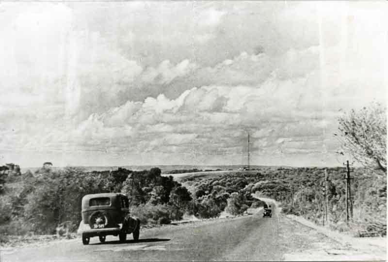
Photograph - Canning Road, Bicton, 1934
1934Subcollections
Overview
View along Canning Road/Highway, Bicton from east of the junction with Preston Point Road looking east. Two cars are driving along the road. The Applecross Wireless Station mast can be seen in the background. Land on either side of the road is undeveloped.
Details
Details
Registration number
cwa-org-137-P868
Item type
Photographs
Themes
Material
Photographic Paper
Width
90 mm
Height or length
120 mm
Place made
Year
Geotag
-32.041010759834, 115.76459806075
Open in Google Maps
Nearest geotagged records:
Nearby places: View all geotagged records »
Open in Google Maps
Nearest geotagged records:
- World War 1, Australia, Western Australia, 2257 UPSON, 10 Light Horse (0.06km away)
- World War 2, Western Australia, Rottnest Island AIF Enlistment, W4436 to WX28696 NEWTON, 1942 (0.18km away)
- World War 2, Western Australia, Rottnest Island AIF Enlistment, W24600 to WX25055 MURPHY, 1942 (0.26km away)
- World War 2, Western Australia, Rottnest Island Enlistments, WP6109 to WX35426 COPE, 1942 (0.28km away)
- World War 2, Western Australia, Rottnest Island Enlistments, W46952 to WX31446 MARTIN, 1942 (0.31km away)
- World War 1, Australia, Western Australia, 1623 MORRIS, 10 Light Horse (0.33km away)
- World War 1, Europe, DOONAN, 1917 (0.38km away)
- World War 2, Western Australia, Rottnest Island AIF Enlistment, W4395 to WX26305 KITSON, 1942 (0.53km away)
- World War 1, Australia, Western Australia, 3236 HORTON, 10 Light Horse (0.56km away)
- AWAS on Rottnest - WF2915 WATERS (0.6km away)
Nearby places: View all geotagged records »
Last modified
Sunday, 21 November, 2021