Chinese Gardens, 1929
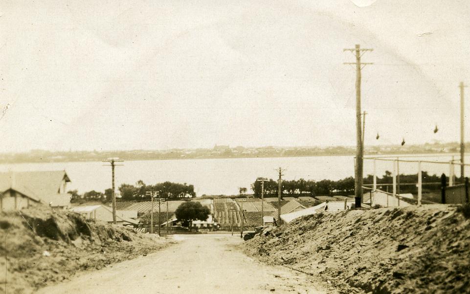
1929Sepia image taken from Forrest Street looking towards the Swan River. Forrest Street has mounds of dirt along the sides of the street and a few houses can be seen towards the river end. Perth City is on the other side of the river.
The market gardens are between Mill Point Road and the Swan River. The gardens are laid out in rectangular plots and different crops can be seen in each plot.
A few buildings can be seen on the Chinese Gardens land, along Mill Point Road.
View of the Chinese Gardens taken from Forrest Street, South Perth.
The Chinese market gardens were established in the late 1880s and covered 11 acres on the South Perth foreshore. The vegetables were purchased by local residents and also sold to wholesalers in James Street Markets, North Perth.
In the late 1940s, there were few Chinese gardeners living and working on the site. In 1951 the South Perth Road Board recommended that all residential buildings be demolished, as the area had been designated for Sir James Mitchell Park. The area reverted to swampland and was not developed until the mid-1970s.
Details
Details
Open in Google Maps
Nearest geotagged records:
- World War 2, Western Australia, Rottnest Island AIF Enlistment, WP6079 to WX35341 AIREY, 1942 (0.36km away)
- World War 1 , Australia Western Australia , 1786 COOPER, Australian Field Artillery, 1914 (0.49km away)
- World War 2, Western Australia, Rottnest Island AIF Enlistment, WX28584 ELLIOTT, 1942 (0.84km away)
- World War 1, Australia, Western Australia, DENSON, 10 Light Horse (0.95km away)
- World War 1, Australia, Western Australia, 947 GILLON, 10 Light Horse (1.1km away)
- AWAS on Rottnest - WF56822 HEPBURN (married GILES) (1.14km away)
- World War 1, Europe, STONE, Australian Field Artillery, 1917 (1.61km away)
- World War 2, Western Australia, Rottnest Island AIF Enlistment, W54314 to WX30696 BRIGGS, 1942 (1.74km away)
- The Old Mill, 1916. (1.75km away)
- World War 2, Australia Western Australia Perth, 1943 (1.8km away)
Nearby places: View all geotagged records »


